The geological aspect of the project is of great import because it helps both date and explain the contexts of the Mesolithic and Palaeolithic tools. Research into the date of the fossilized beaches at Preveli has already begun, and future analyses will greater clarify their date. Presently the project is conducting micromorphological analysis of the Damnoni excavation soils and sediments to understand their depositional history, and utilizing Optical Stimulated Luminescence (OSL) to date the period of occupation.
Description of the Geology
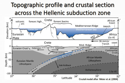
The southwestern coast of Crete is an active geologic environment. The rocks exposed at the Earth’s surface here are a mélange brought together as a result of the long-lived and ongoing collision and subduction of the African tectonic plate beneath Europe. During the subduction process, where African crust is pushed beneath Europe, some of the sediment and rock is scraped off the African plate, building a large wedge (much like snow in front of a snow shovel) that thickens to the north from the central Mediterranean Sea to this island of Crete. The bedrock geology of Crete is the story of the accumulation of this off-scraped rock and sediment into a complicated mixture of marine sedimentary (limestone, sandstone, shale) and volcanic rocks (basalt) that are cut by numerous faults.
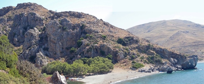
The south coast of Crete is backed by uplifted mountains of limestone and lower plains of more easily weathered rock like mudstone and sandstones. Inactive and active faults cut across the rock units, juxtaposing rocks of different types against one another. Where rivers flow across the resistant limestone, they have formed narrow, deeply-incised river gorges, such as the Megas Potamos at Preveli. Small caves often form along the coast as rain water slowly dissolves away the limestone bedrock. Flanking the coast are flights (arranged in a stair-step fashion) of marine terraces (old beaches) corresponding to intervals of global sea level high stands during the last 130,000 years. The preservation of these old beach deposits has been made possible by the slow, yet steady uplift of Crete above sea level (1 to 2 mm/yr).
The underlying geology of the Plakias region affected our archaeological research, and certainly factored into the decisions of the first inhabitants of the island. For example, the location and nature of faults, which can control the location of springs and surface water, cave shelters, and access to resistant quartzite for tool making were factors that likely determined prehistoric site preferences by the islands earlier inhabitants. Active tectonics and earth-surface processes have worked for hundreds of thousands of years to both preserve sites in some cases and to destroy them in others. Perhaps the most important of these processes is the ongoing tectonic uplift of the area. This uplift creates steep slopes that can accelerate the deterioration of the caves and rockshelters that were the focus of prehistoric human land use, and the erosion of unconsolidated sediments has affected the preservation of early prehistoric sites everywhere.
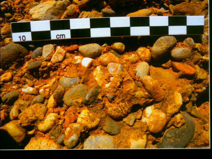
Close-up of a raised marine terrace on the east flank of the Preveli Gorge. Notice the shell and water-worn pebbles. These occur at over 90 meters above sea level.
Tectonic uplift of the island has also aided in the preservation of old beach deposits (now cemented together like concrete) by raising them above sea level, preserving in some cases evidence of prehistoric human activity within them. For example, at Preveli site 2, lithic artifacts made out of quartzite are cemented together with regular beach gravels in old marine terraces now tens-of-meters above sea level. In order for the artifacts to have been incorporated in the beach gravels, they must have been deposited on the beach before it became cemented together and later uplifted by tectonic activity. In other cases, such as at Preveli site 7, Palaeolithic artifacts are found within paleosols (buried and/or fossil soils). Thus, determining the age of these old beaches and soils are a critical component in estimating when the first humans arrived on the island of Crete.
K. Wegmann
General geology of the excavation area of Damnoni Cave
A flight of marine terraces are observed in the excavated area. The dirt road in front of the excavation is actually on top of such a terrace that has an approximate height of about 23 meters. Datum point T1 (22.556 m) is located on a remnant of the terrace planation surface on the road. At about the same height a small shallow cave is found about 50m to the west of the site, presumably a sea cave. A notch is observed in one side of the cave with its apex at a height of 23.7 m. The cave has a hanging bioherm reef and shelly sand and gravel beach complex. A few meters to the east another reef clastic beach complex is found (24. 305 m) and even further to the east another small cavity is found at about the same elevation.
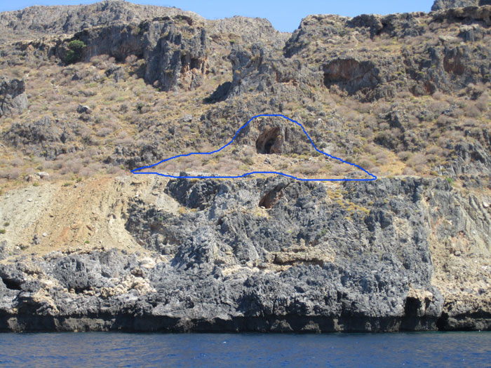
Damnoni Cave from the sea. The blue line demarcates the cave and area of excavation in 2011 (photo by Kylie Waltz). Notice the uplifted wave notch at the water’s edge, which dates to a massive earthquake in 365 A.D.
A few meters above the first aforementioned cave there is a remnant of a wave-cut bench which is correlated to a remnant of a reef terrace a few meters to the west where the second reef clastic beach complex is located, all at about the same height of ca 27 m. Further up at least four more major marine terraces are observed two of the having thick reef drapes. The first one was measured at ca. 35-36 m and the second, a small one, is only a couple of meters above. However, it appears that the prominent 35-36 planation surface is accompanied by smaller ones, a couple of meters above and below.
To the east of the excavation area there is a large cave with a leveled floor at an approximate height of 28 m. This base consists of reef deposits marking a prominent sea level hightstand. At the back of the cave inside a slot a ca 3m thick gravelly deposit is found on top of the floor capped by travertine. The top of the presumably beach gravel is correlated with a line of notches at about 32 m. Mollusk borings are widespread in the cave and extent several meters above the beach gravel. The cave was probably a karstic conduit that was cut by former sea level hightstands and some speleothems at its back are probably related to this period. Borings are also found on the speleothems and therefore postdate their formation.
At the excavation area the floor of the cave DM3 surface is at 30 m. The cave is a remnant karstic formation but a notch close to its base and several lithophaga borings above suggests the cutting of the cave by a sea level highstand. The apex of the notch was measured to ca. 32 m probably correlated to the prominent 35 m prominent highstand observed in the area. A remnant of a wave-cut bench on the east side of the cave is in continuation of the notch inside the cave. The walls of the cave below the notch and the walls of the wave-cut bench are quite vertical but are now covered by clastic sediments. In the continuation of the west wall of the cave the bedrock appears a few meters below but there is no indication of the bedrock directly in front of the cave all along the slope down to the dirt road. The fact that notches at the same height are observed in the large cave to the east of the site might suggest that this cave can be used as a model for the form of the cave in the excavation area. Therefore there is a strong possibility that the cave floor is actually at about 27 m and there is 3 m of fill above it.
As already mentioned above, marine benches, notches and reef platforms in the area of the excavation are well clustered in two major highstands at ca. 24 and 35 m well correlated to the ones found in the Preveli area dated to approximately 50 and 57 Ka respectively. However, there is evidence of several substages in each highstand probably due to minor fluctuations of the sea level. Indeed, the gravel deposits inside the large cave to the east and presumably the associated notches at 32 m height postdate the formation of the reef platform of the floor of the cave at ca 28 m. This fluctuation cannot be interpreted by uplift since the higher features are actually younger than the lower features.
The excavation area
In front of the cave DM3 the slope makes at least two breaks at approximately 27-26 m and 24-23 m quite well correlated with the two of the marine terraces in the vicinity of the cave. The first test trench was made at the flat area immediately below the first break and the second trench on the lower flat area. Based on observations made on erosion gullies we expect to find from top to bottom the following strata in the sediments at the bottom of the sloping area in front of the cave.
- A dark gray sandy silt top soil rich in organic matter having occasionally a granular soil structure. It is normally loose but more firm horizons are expected in areas where its thickness increases.
- An orange firm clay-rich sandy layer, with homogeneous massive appearance. It is moderately affected by pedogenetic processes.
- A red sandy clay paleosol with fine angular blocky soil structure. It is probably a B horizon of a soil.
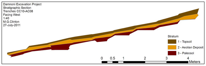
Computer generated cross-section of the Damnoni stratigraphy (by Miriam Clinton).
The aeolian sand deposits should be correlated with lower sea levels than the present because a coastal plain in front of the modern coastal cliff is necessary for providing the source of the aeolian sand. The paleosol implies a prolonged period of stability, plant colonization and soil fauna activity.
P. Karkanas